Notice: Undefined variable: show_stats in /usr/home/syncrostudio.com/html/wp-content/plugins/stats/stats.php on line 1385

SYNCRO architecture studio

Architecture, Planning and Urban Design – San Antonio, Texas

  • project galleries
    • Tolteca Studios – Conceptual Design
    • DUSTOFF Memorial Fort Sam Houston
    • Museum Master Plan
    • Civic Art Project – Karen Mahaffy
    • Olmos Park Residence
    • Monte Vista Addition
    • Karnes County Offices on the Square
    • Urban Residence
    • Holland Avenue Residence – Gallery
    • Environmental Laboratory
    • Lighthouse International
    • The Crossroads – Affordable Housing
    • The Berkeley Carroll School
    • Always B Ranch – Residence
  • project types
    • educational
    • civic and cultural
    • healthcare and housing
    • homes
    • urban design and planning
    • workplaces
  • blog
    • architecture
    • events
    • publications
    • urban
  • about
    • about David Bogle
    • Privacy Policy
  • contact

urban

Archives

2014/01/02 by David Bogle

2030 District is forming in San Antonio

Seattle's 2030 District birds' eye view.

Seattle’s 2030 District birds’ eye view.


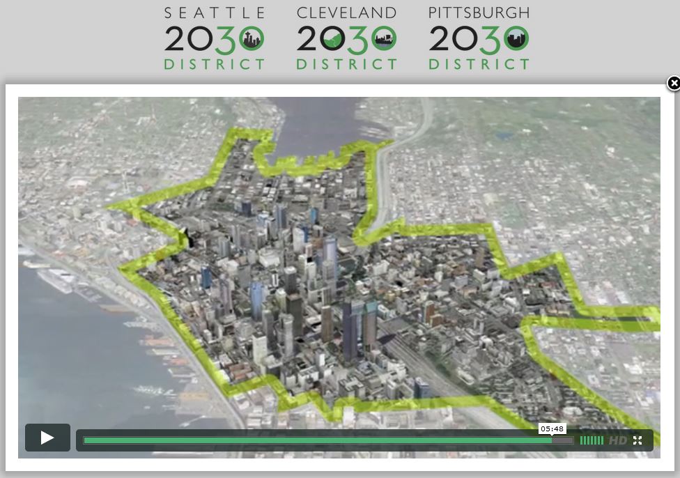
In 2011 Architecture 2030 launched “2030 Districts” and now a 2030 District is forming in San Antonio. There is a general understanding of energy and sustainability issues at the scale of a building. The interrelationship among all the elements of the built environment is much more difficult to grasp (and measure.) Urban development patterns of buildings, people, plants and ecosystems, pavement, transportation, infrastructure of utilities, etc. make up the whole of urban systems. Urban systems have a great potential for energy savings and can only be dealt with effectively comprehensively, or as a whole. Urban designers, deep-pocketed real estate developers and city planners think and work at this scale, but mostly on a project-by-project or piecemeal basis. Municipal planning agencies don’t have enough power to bring comprehensive planning into its full potential for sustainability progress.

2030 Districts is a private sector-led sustainability initiative on the scale of the city or district. This win-win solution’s theory goes that businesses can be more successful – strengthen their market share – while saving energy, cutting greenhouse gas emissions and developing a more livable city with this higher level of collaboration toward urban sustainability.

Please see the 2030 web site in the link to the right for more background information and come to the AIA San Antonio’s new Center for Architecture on January 9 to join in the local effort for a more sustainable downtown.

Below is an excerpt from 2030districts.org:

Across the United States, 2030 Districts are being formed to meet the energy, water and vehicle emissions targets called for by Architecture 2030 in the 2030 Challenge for Planning.

Through unique public/private partnerships, property owners and managers are coming together with local governments, businesses, and community stakeholders to provide a business model for urban sustainability through collaboration, leveraged financing, and shared resources. Together, they are developing and implementing creative strategies, best practices, and verification methods for measuring progress towards a common goal.

Established in Seattle, 2030 Districts are at the forefront of regional – and national – grassroots efforts to create strong environmental partnerships, coalitions, and collaboration around ambitious, measurable and achievable goals.


2030 District web site for more background information.

Eventbrite link to January 9 Launch party at AIA San Antonio.

Posted in blog, events, urban · 1 Reply ·

Archives

2013/12/30 by David Bogle

Citizen-Input Public-Planning Processes

tonio Proposed Solution #1

This image is NOT the plan proposed by H-E-B, but it is illustrative of a Win-Win Solution to keep Main Avenue open.


San Antonio Current reporter Mary Tuma contacted me for her article following up on H-E-B’s plan to privatize the section of Main Avenue on the south edge of downtown.   H-E-B’s bid to to create a suburban style campus downtown sailed through city council as widely expected. Council’s action is an approval to create an automobile-oriented superblock, which not only is contrary to urban planning best-practice principles; but more heinously, it is contrary to the democratic institution of community-input planning the city has been conducting. It is reveals an ugly side of our city’s processes: special interest lobbying and top-down management.

The citizen-input public-planning processes which occurred over the past few years along with enacted policies for redeveloping a more livable downtown should stand, be respected and should have categorically thwarted the private corporation’s deep-pocket real estate play that contradicts the public-input plans. H-E-B should have come to the community planning meetings and openly voiced their objectives. They should have sought resolution in the public-planning arena. Instead, public land, a right-of-way, is being traded for a gas station and jobs. Job creation is an important component of the community’s plan, but not at the expense of the larger goal: to create livable communities that integrate all goals.

The sad part of this situation is that H-E-B could accommodate a higher number of employees without taking over public land (See illustration by imagineSanAntonio, above, and as issued in their Press Release.) The city could have worked with H-E-B to create a vibrant campus that would reflect the thriving, progressive city Mayor Castro’s SA2020 initiative projects. The surrounding community could have retained its vision for livability.  

Thinking idealistically, I wonder how can our city evolve so that powerful corporate interests and the real estate oligopoly genuinely participate in community-based urban planning processes?

Below are a few excerpts from the article.


….Proponents of the $100 million expansion point to the allure of job growth. While the promise of new employment brought on by the 10,000- square-foot store remained vague for some time, the City’s Development Office cleared the confusion up at the early December meeting, saying H-E-B will employ 800 workers by 2020 and an additional 800 employees by 2030—50 percent of these will be new jobs. Mayor Julián Castro said he understood concerns of the residents affected by the partial Main Street closure but that the chance for economic development was worth the investment.

“We have on the table an opportunity to create a significant number of jobs in the urban core of the city and create a grocery store that I believe will further catalyze the revitalization of downtown,” said Castro, of the 1,600 estimated jobs.

To mitigate walkability and cyclist concerns, H-E-B also promised to create a 30-foot pedestrian and bike amenity zone, re-open Whitley and Dwyer Streets, ensure ADA-friendly walking paths, arrange and replace or preserve the bike route and pedestrian path through South Main Avenue and enhance pedestrian signals and crossings. The street upgrades must be made before closing Main Avenue, City representatives said.

However, the mitigation improvements didn’t do much to help assuage critics’ qualms.

“Those ideas don’t alleviate any of those concerns from citizens, myself included,” David Bogle, a local architect and University of Texas at San Antonio College of Architecture professor, tells the Current. “They’ve broken the street grid and connectivity already, it’s not mitigating the real problem they’ve created.”

“To use their term, the ’30-foot amenity zone’ is just sort of window dressing on their own property,” says Bogle. “… It’s just one block long they’re talking about improving; it’s a conceptual proposal that is not something that is very feasible or workable and it will just create unsafe situations.”

Bogle, co-chair of the local chapter of the AIA Urban Affairs Committee, has presented against the H-E-B site at City zoning and planning commission meetings. He argues the plan is “antithetical” to most of the citizen and public input policies that are in place here in San Antonio, pointing to the Lone Star Community Plan, which shows residents favor high-density, public transit-oriented, mixed-use developments in the core. “What they are proposing is anything but this,” says Bogle. “It’s a low-density, single-use parcel and very much automobile oriented—it’s not what our downtown needs.” In fact, says Bogle, the new store will negatively affect SA2020 goals, including miles traveled, public transit ridership, travel time and air quality indexes as well as walkability scores….

via H-E-B’s Main Ave. Plans Passed Council, Now Citizens Want Oversight – News and Politics – San Antonio Current. By Mary Tuma.

Posted in blog, publications, urban · Leave a Reply ·

Archives

2013/12/26 by David Bogle

Streets for the people – SA Current


Businesses on Broadway are increasingly pedestrian- and bike-friendly. The street itself? Not so much.  Photo by Callie Enlow.

Businesses on Broadway are increasingly pedestrian- and bike-friendly. The street itself? Not so much. Photo by Callie Enlow.

Streets for the people is an article about San Antonio’s downtown streets issues – at least about a few of our many street issues. Automobile-oriented street spaces are what we have inherited, and while they provide connectivity for people who wear cars everyday, they choke the city’s potential to transform into a walkable, more sustainable city.
Below is an excerpt. Please link to read the entire article.

….we really need a citywide conversation and rethinking of how our major streets work, and for whom. Fortunately, we have some guides for ways to think better and smarter about streets.

Former San Francisco planning chief Allan Jacobs, in his book Great Streets, provides a host of models and guidelines from around the world. Jacobs describes the best streets as “comfortable to walk along with leisure and safety,”—streets that are equally usable by both drivers and pedestrians. He also notes the importance of streets as social spaces, where people can socialize and interact. The basic elements of “great”—or even just better—streets are now widely recognized and developed, employed in such ways as San Francisco’s 2010 Better Streets Plan. They include sidewalks sufficiently wide to accommodate both walking and gathering, with benches and shaded areas as well as sidewalk cafes and kiosks. Improved street ecology is also important, including an abundance of street trees and greenery, effective management of storm water and thoughtful placement of utilities (that means not building sidewalks with poles right in the middle)….

via Cityscrapes: Streets for the people – News and Politics – San Antonio Current

By Heywood Sanders

Published: December 4, 2013.

Posted in blog, publications, urban · Leave a Reply ·

Archives

2013/12/11 by David Bogle

Why cul-de-sacs are bad for your health

Aerial photos above showing approximately the same portions of San Antonio analyzed below.

Aerial photos above showing approximately the same portions of San Antonio analyzed below.

A new book, Happy City by Charles Montgomery, is featured on slate.com.

To bring this home to San Antonio I have drawn the illustration below from a study done by a former VIA employee regarding urban connectivity as required for walkability and public transit. At the top of the page I have paired comparative aerial photographs of approximately the same two areas: on the left the connected, walkable and healthy part of town – on the right is the disconnected, auto-dependent and bad-for-your-health sprawl.

I suggest that the old adage “you are what you eat” is being rewritten. You are where you live!

Analysis of two areas of San Antonio showing different levels of connectivity.

Analysis of two areas of San Antonio showing different connectivity levels of connectivity.

….investigators from the Georgia Institute of Technology led by Lawrence Frank discovered that people’s environments were shaping their travel behavior and their bodies. They could actually predict how fat people were by where they lived in the city.

Frank found that a white male living in Midtown, a lively district near Atlanta’s downtown, was likely to weigh 10 pounds less than his identical twin living out in a place like, say, Mableton, in the cul-de-sac archipelago that surrounds Atlanta, simply because the Midtowner would be twice as likely to get enough exercise every day….

….Connectivity counts: More intersections mean more walking, and more disconnected cul-de-sacs mean more driving. People who live in neighborhoods with latticeworklike streets actually drive 26 percent fewer miles than people in the cul-de-sac forest.

via Why cul-de-sacs are bad for your health: Happy City by Charles Montgomery.

Posted in blog, urban ·

Archives

2013/12/08 by David Bogle

…Proposal Clears Planning Commission…

Red-dotted line is currently South Main Avenue.  The entire northern half of the soon-to-be superblock is "planned" to remain underutilized and auto-oriented - this on the side facing downtown San Antonio.

Red-dotted line is currently South Main Avenue. The entire northern half of the soon-to-be superblock is “planned” to remain underutilized and auto-oriented – this on the side facing downtown San Antonio.


Iris Dimmick, of the Rivard Report, wanted to speak to me after planning commission vote, and her article, “H-E-B Proposal Clears Planning Commission, Moves to City Council” is in the link to the right with some excerpts below in the grey box. First, here’s a little background and a curt summary of where things stand.

I made presentations to the zoning commission on Tuesday and to the planning commission on Wednesday. I emphasized the fact that the proposed plan by HEB does not comply with the relevant community-input land use plan. “High-Density Mixed-Use” is the community vision, per the Lone Star Community Plan. Bob Wise spoke and presented the win-win solutions from imagineSanAntonio per his article in the Rivard Report.

Zoning commissioners voted unanimously to allow, with a special use authorization, a gas station in the “Downtown” zone, against the land use plan. Like dominoes, and against the City’s 2011 Strategic Framework Plan, planning commissioners voted unanimously to declare as surplus, and to abandon, the public right-of-way South Main Avenue, dismantling the potential of this thoroughfare to become a complete street and to connect to other complete streets.

City Council cinched the deal on Thursday, voting to support HEB corporation’s plan to create a huge superblock in downtown San Antonio. Per their proposed plan it will have a new gas station and store with surface parking lots on its (otherwise potentially) most urban, north-east corner. This new privately-owned parcel will be almost twice as large as any other major American city’s largest superblock!

Architect and urban design professor David Bogle pointed to the Lone Star Community Plan’s call for “high density mixed use” at the sites of the proposed grocery store and current H-E-B employee parking lots.

The proposed grocery store and gas station are “low density, single use,” Bogle said. ”The privatization of a street at this location would work against goals established for downtown.”

….

“These issues are not going to stop after South Main (Avenue) is sold,” Bogle said after the round of “yay” votes approved the closure. Tomorrow at City Council, “we’ll reiterate the valid concerns of the citizens … and the costs (of this plan) dismissed by the government.”

via H-E-B Proposal Clears Planning Commission, Moves to City Council | The Rivard Report.

Posted in architecture, blog, events, urban · Leave a Reply ·

Archives

2013/10/29 by David Bogle

Dialogues In Planning: Urban Connectivity


Urban Connectivity Poster Download

Urban Connectivity Poster Download


UTSA Center for Urban and Regional Planning invited me to moderate a panel discussion at their “Dialogues in Planning” forum next Monday, November 4th, entitled “Urban Connectivity.” Please join us and bring your questions for the panelists.

Streets play an important role in the lives of the city dwellers. The form, function and character of communities are defined by the public realm which is largely our street network. Well-designed street networks connect us in safe, direct, and convenient ways and allow options for various forms of transportation, from walking to bicycling to driving to public transit. Poorly planned cities disconnect the street networks, divide neighborhoods, limit accessibility to locations, and increase vehicular congestion. This dialogue will contemplate what streets and connectivity mean for San Antonio’s urban core and its neighborhoods, as we head into what Mayor Julian Castro has called the Decade of Downtown.

via Dialogues In Planning: Urban Connectivity | imagine San Antonio.

November 4, 2013 6 – 7:30 pm
University of Texas at San Antonio – Downtown Campus
The downtown UTSA campus is accessible to bus routes #20, #66, #68, #70, #75, #76, #79, #93 and Primo (#100)
Frio Street Building, Multi-Purpose Room (1.402)
Free Parking at UTSA Lot D-3, underneath I-35

Posted in blog, events, urban · Leave a Reply ·

Archives

2013/09/25 by David Bogle

Cultural Landscape of San Antonio’s Westside


conocimiento_cover
Claudia Guerra has been analyzing the cultural landscape and spirit of place on San Antonio’s Westside. Recently she applied to the Graham Foundation for a grant to further her research. SYNCRO architecture studio has agreed to finance a portion of the study and lend support with some supplies and a mapping exercise. Linked here, by the cover, above, and in the right-hand column, is the photo essay distilled from her academic paper presented at the National Council of Chicano and Chicana Studies in March 2013.


Cultural Landscape of San Antonio’s Westside Photo Essay

Posted in blog, civic and cultural, publications, urban, urban design and planning · Leave a Reply ·
Newer posts →

Recent Posts

  • Hope Center 2
  • We Are Still In – Countering Climate Change
  • Pawderosa Ranch Announces Dog Daycare Project
  • “suburban development is an experiment” – Growth Ponzi Scheme – Strong Towns

All content © 2025 by SYNCRO architecture studio. Sidewinder WordPress Theme by Graph Paper Press