Notice: Undefined variable: show_stats in /usr/home/syncrostudio.com/html/wp-content/plugins/stats/stats.php on line 1385

SYNCRO architecture studio

Architecture, Planning and Urban Design – San Antonio, Texas

  • project galleries
    • Tolteca Studios – Conceptual Design
    • DUSTOFF Memorial Fort Sam Houston
    • Museum Master Plan
    • Civic Art Project – Karen Mahaffy
    • Olmos Park Residence
    • Monte Vista Addition
    • Karnes County Offices on the Square
    • Urban Residence
    • Holland Avenue Residence – Gallery
    • Environmental Laboratory
    • Lighthouse International
    • The Crossroads – Affordable Housing
    • The Berkeley Carroll School
    • Always B Ranch – Residence
  • project types
    • educational
    • civic and cultural
    • healthcare and housing
    • homes
    • urban design and planning
    • workplaces
  • blog
    • architecture
    • events
    • publications
    • urban
  • about
    • about David Bogle
    • Privacy Policy
  • contact

blog

Archives

2012/04/18 by David Bogle

TEX-FAB 3 Symposium comes to San Antonio
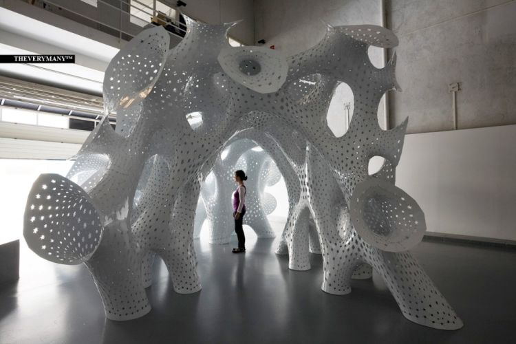

Marc Fornes – FRAC Centre, Orleans


I was pleased to be able to attend my second Tex-Fab symposium and workshops this past weekend in downtown San Antonio, just a few minutes from my home. This annual event features leaders in the digital design and fabrication field, a growing acumen among environmental designers worldwide. Tex-Fab is an organization promoting the application of technologies in industry to the production of architecture. From their website: “Within Texas there is an emerging network of companies, institutions, and individuals focusing on the exploration of parametric design and the digital production of building components. Specifically, there is a growing opportunity for collaborative exchange between the academic, technical, and professional communities by leveraging the immense resources found in some of the largest metropolitan centers across the United States.”

The event was hosted by the College of Architecture at UTSA. Workshops included 3-D computer design topics from introductory to advanced levels. Building information modeling (BIM) techniques with Autodesk’s REVIT was my focus, and we concentrated on parametric controls of geometry. We want to be able to model buildings and components, then be able to easily manipulate and control changes to study alternatives. You might think of it as a virtual row of clay models, each a variation on an idea. My hands aren’t dirty, though, and there is a stream of data available to help me compare alternatives. Everything from quantity take-offs of materials, to energy consumption data, solar radiation intensity and wind interaction can be simulated in the computer model versions of the clay.
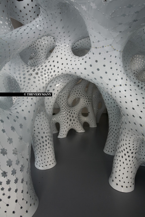

Marc Fornes – FRAC Centre, Orleans


Marc Fornes made the keynote lecture running through the computational design journey and his “failures” over the last ten years. The point was With each successful project he has carried out there have been surprises from which he has learned. His term for what his company – THEVERYMANY™ – does is “precise indetermination…” so he is constantly open to the unexpected joys of design. The example shown is made of thousands of thin aluminum pieces precisely cut by computer numeric controlled (CNC) machining, and hand riveted together.

Posted in blog · Leave a Reply ·

Archives

2012/02/28 by David Bogle

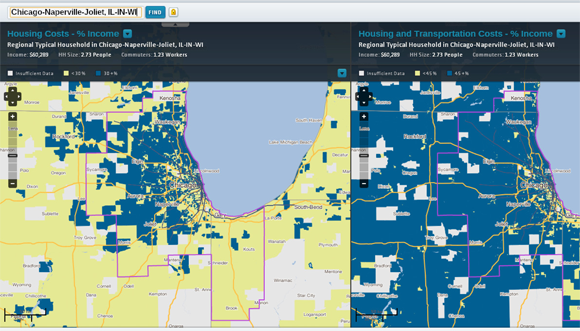
Affordability = Housing Costs plus Transportation Costs

Housing + Transportation Cost

Afordability Index = Housing + Transportation Cost


Housing and Transportation costs, taken together, represent the true cost of living in a particular location better than looking at housing costs alone. A new, updated web-based tool unveiled recently by the Center for Neighborhood Technology to display housing and transportation costs. This Affordability Index could be useful to compare places to live if you might be moving, but also to understand a more complete picture of how affordable housing may be strategically located to maximum effect.

Additionally, it tells the story of how compact development patterns provide opportunities to reduce energy consumption and carbon emissions.


The Center for Neighborhood Technology is:

“An Innovations Center for Urban Sustainability

Founded in 1978, the Center for Neighborhood Technology has been a leader in promoting more livable and sustainable urban communities. In fact, our work focused on sustainable development before the term became as popular as it is today. As a creative think-and-do-tank, we research, invent, and test urban strategies that use resources more efficiently and more equitably.”
source: http://www.cnt.org/about

Posted in blog · Leave a Reply ·

Archives

2011/12/04 by David Bogle

Urban Public Realm Design trumps Individual Works of Architecture


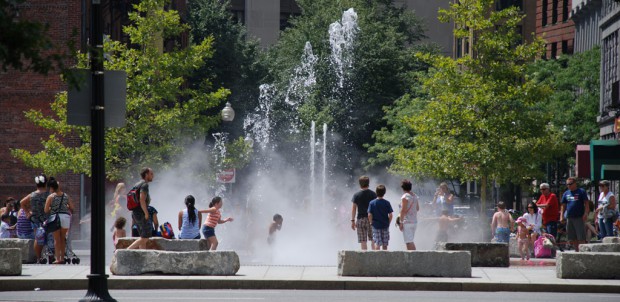
Street space improvements, Wharf District Park, Boston

People playing in fountains - Wharf District Park, Boston


This article,
Treasuring Urban Oases
inspired me to write a little bit about the public realm design and urban development. Urban dwellers want our cities to become better places to live. We want our economies to grow and to maintain or evolve our city’s identities. The direction this takes us, widely agreed among urban planners, is toward walkable neighborhoods with a compact enough city form (a.k.a. density) to support multiple modes of public transit. This is a market-driven fact of urban economies – the most valuable urban properties are in what the American Institute of Architects calls Livable Communities. A close proximity among workplaces, residences and green spaces is a major part of the equation, and high-quality public spaces are more important than large quantities of public space.

The public space type that is most prevalent and important is the street space. Streets are not just the pavement for vehicles, but the entire right-of-way plus private frontages on each side. Planners and urbanists, to address the more holistic aspect of the “street,” now refer to “complete streets” which provide accommodation of pedestrian, bicycle, transit, as well as automobile travel. San Antonio has adopted a complete streets policy.


Treasuring Urban Oases

By MICHAEL KIMMELMAN
Published: December 2, 2011
Alexander Garvin, an architect and urban planner, has spent the better part of the last half-century thinking about New York City’s public spaces.

Posted in blog · Leave a Reply ·
Newer posts →

Recent Posts

  • Hope Center 2
  • We Are Still In – Countering Climate Change
  • Pawderosa Ranch Announces Dog Daycare Project
  • “suburban development is an experiment” – Growth Ponzi Scheme – Strong Towns

All content © 2025 by SYNCRO architecture studio. Sidewinder WordPress Theme by Graph Paper Press